The CZO Multiscale TROPIcal CatchmentS (M-TROPICS) provides the international scientific community with unique decennial time series of meteorological, hydrological, geochemical, and ecological variables in tropical environments. The CZO M-TROPICS involves academic and governmental partners in tropical countries (Cameroun, India, Lao PDR, and Vietnam) and is included in the Research Infrastructure OZCAR, the French contribution to the international CZO initiative.
Objectives
Long-term monitoring of the variables needed for establishing water, biogeochemical (including particulate matter), and energy budgets: water and inorganic and organic matter in solution (major anions and cations, carbon), in suspension (suspended particulate matter, including organic carbon), and bed particulate matter
Impact assessment of global change (land-use, climate) on water fluxes, chemical weathering, and physical erosion
Data and information dissemination to the scientific and stakeholder communities
Capacity building in the field of catchment hydrology and soil erosion, through on-the-job training, teaching, and student internships, and basic geochemistry through analytical platforms
Recommendations on land use policy to the national authorities
Strengths
Multiscaleapproach, both spatially (from microplot to catchment and larger river basins scales) and temporally (from sub-hourly to multi-decennial time-series)
Multidisciplinaryapproach, currently involving hydrology, biogeochemistry, soil science, agronomy, ecology, remote sensing, experimentation, and modelling
Achievements
Besides data collection and dissemination, the achievements of M-TROPICS on November 2022 are:
257 scientific publications in international journals
33 scientific publications in national journals
1 special issue in the Lao Journal of Agriculture and Forestry (2008): Management of soil erosion and water resources in the uplands of Lao P.D.R., by Ribolzi O. (Ed.), Pierret A. (Ed.), Gebbie L. (Ed.), Sengtaheuanghoung O. (Ed.), and Chanphengxay M. (Pref.)
57 PhDs, 7 post-docs, 6 HDR, and 281 MSc, BSc and Agric. Eng. degrees
Rationale
Hand pump well, Berambadi catchment.
The Earth Critical Zone (CZ) is defined as the thin layer between the top of the canopy and the bottom of groundwater aquifer in which complex interactions involving rock, soil water, air and living organisms regulate the natural habitat and determine the availability of life sustaining resources. This concept brings together scientific disciplines in the aim to tackle crucial environmental issues regarding how the various components of the CZ react to global changes, including land use and climate changes:
What are the water, solute, and particulate fluxes exported from tropical catchments?
What is the impact of rapid land use changes on hydrology, water quality, soil resources?
The strategies adopted to answer these questions are often integrated approaches on experimental catchments, where hydrological, sedimentary, biogeochemical and ecological studies can be coupled. Acquiring simultaneous time series of meteorological, hydrological, geochemical, and ecological data over decades on river systems (both small experimental watersheds and larger basins) representative of the diversity of ecosystems is pivotal for the understanding of these processes, building integrated modelling and for proposing predictive scenarios.
Among the Critical Zone Observatories (CZOs) that have been implemented by the Earth Science community in the past 30 years, very few were set up in the Tropics despite the huge importance of these regions in terms of population density, fast-changing land use, biodiversity hotspots, biomass stock on continents (humid forests), size of river systems. In addition, rainfall in the Tropics is mostly governed by monsoon systems, which are particularly sensitive to climate change.
Houay Pano catchment.
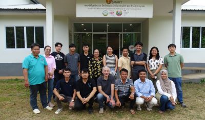
Workshop
SMART training session 2025
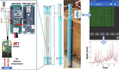
Sensors capable of accurately measuring water level exist on the market, but they are generally expensive, fragile and ill-suited to the aggressive conditions encountered in rivers, particularly in the inter-tropical zone. A self-contained, float-controlled water level gauge based on visible laser Time-of-Flight (ToF) technology, designed as an integrated device for automatically measuring and recording water […]
Articles
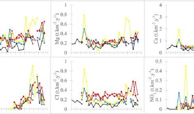
Exploring the nexus between hydroclimatic variability, population growth, land use land cover change, and long-term upper Nyong Basin River chemistry (Central Africa rainforest)
Hydrological and hydrogeochemical functioning of rivers depends on the relationship between climatic variability, land use and land cover change (LULCC), and population dynamics. However, there is a scientific gap on this relationship in the humid tropical zone of Central Africa. This study, led by David Eric Komba, aims to fill this gap by examining the […]
Articles
A float-controlled self-contained laser gauge for monitoring river levels in tropical environments
In this paper Dr Pierret and colleagues present the design, construction and performance of a self-contained float-controlled water level gauge for monitoring water levels in streams and small rivers. This device is inexpensive (cost of about EUR 220), easy to build (no electronics skills or specialized tools required; assembled in a few hours) and straightforward […]
Reuse of bottom sediment from reservoirs to cropland is a promising agroecological practice that must be rationalized
In semi-arid areas, intermittent streams are often equipped with small reservoirs to store water for irrigation and/or groundwater recharge, and to capture sediments lost through erosion. These reservoirs must be periodically desilted to maintain their storage capacity. While bottom sediments are generally considered waste, their reuse in agricultural fields is a centuries-old practice in India. […]
Articles
Soil erosion control in tree plantations on steep slopes: Runoff water andsediment trapping efficiency of riparian grass buffer in mountainoushumid tropics
Riparian grass buffers reduce the velocity of water flowing over the soil surface during storms, capturing surface runoff (SR) and trapping soil particles eroded from cultivated slopes. Rarely quantified under steep slope conditions (>45 %), this phenomenon probably occurs in many mountain agroecosystems in the humid tropics. In Southeast Asia, teak plantations are often established on […]
Events
Inauguration of the SMART station in Ban Laksip
The Sustainable Mountain Agroecosystems Research and Training (SMART) station was inaugurated on Tuesday November 19, in the presence of the Vice-Ministry of Agriculture and Forestry Dr. Chanthakhone BOUALAPHANE, Her Excellency the Ambassador of France in Lao PDR Ms. Siv-Leng CHHUOR, and the Vice-Governor of the Luang Prabang Province Ms. Siliphone SOUPHUNTHONG. The SMART station is […]
We use cookies to guarantee you the best experience on our site, and to make statistics of attendance (Google Analytics). If you continue to use this site we will assume that you are happy with it.