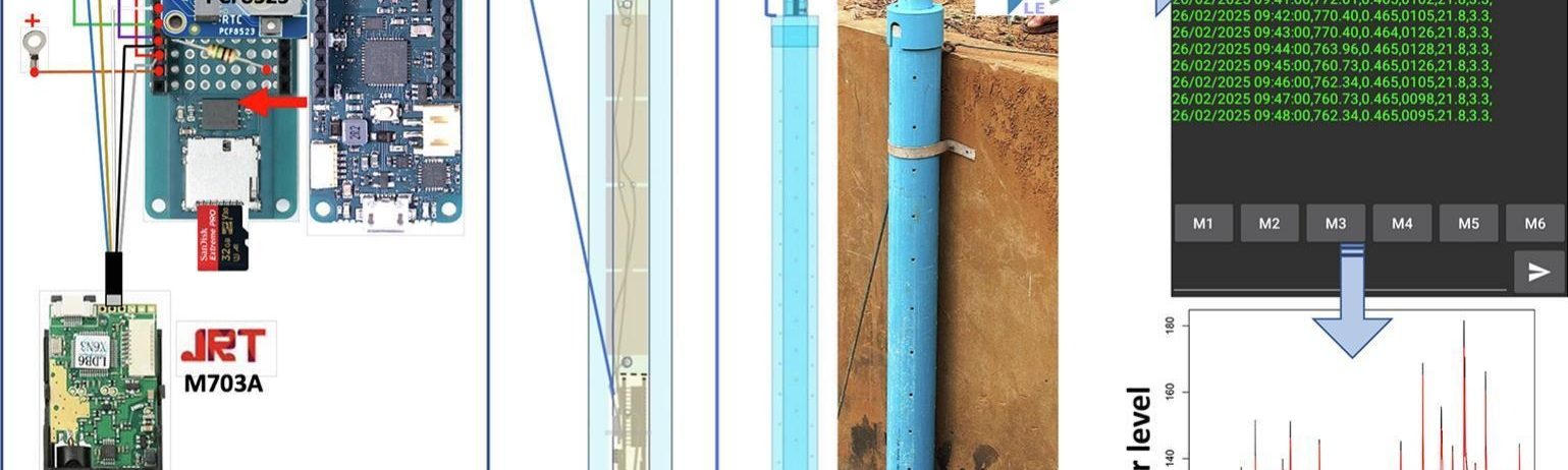
A float-controlled self-contained laser gauge for monitoring river levels in tropical environments

In this paper Dr Pierret and colleagues present the design, construction and performance of a self-contained float-controlled water level gauge for monitoring water levels in streams and small rivers. This device is inexpensive (cost of about EUR 220), easy to build (no electronics skills or specialized tools required; assembled in a few hours) and straightforward to use. The gauge remains autonomously operational for several weeks in remote locations without the need for an external power supply or solar panel and in the harsh tropical climatic conditions. Data can be downloaded wirelessly in the field using an Android smartphone or tablet. This gauge is capable of a measurement precision of ±1 mm at temperatures ranging from 20 to 30 °C and accurate to within 2 mm of manual readings in a controlled laboratory environment. In the field, the mean absolute error (MAE) of measurements taken with the water level gauge compared to that obtained with the OTT-SE200 − a commercial float-controlled angle encoder water level gauge − over a full tropical rainy season and for a measurement range of 0.5 m, was 2.6 mm (n = 8,017). This paper was published open access in the HardwareX journal.

More news

Exploring the nexus between hydroclimatic variability, population growth, land use land cover change, and long-term upper Nyong Basin River chemistry (Central Africa rainforest)

Hydrological and hydrogeochemical functioning of rivers depends on the relationship between climatic variability, land use and land cover change (LULCC), and population dynamics. However, there is a scientific gap on this relationship in the humid tropical zone of Central Africa. This study, led by David Eric Komba, aims to fill this gap by examining the […]

Reuse of bottom sediment from reservoirs to cropland is a promising agroecological practice that must be rationalized

In semi-arid areas, intermittent streams are often equipped with small reservoirs to store water for irrigation and/or groundwater recharge, and to capture sediments lost through erosion. These reservoirs must be periodically desilted to maintain their storage capacity. While bottom sediments are generally considered waste, their reuse in agricultural fields is a centuries-old practice in India. […]

Soil erosion control in tree plantations on steep slopes: Runoff water andsediment trapping efficiency of riparian grass buffer in mountainoushumid tropics

Riparian grass buffers reduce the velocity of water flowing over the soil surface during storms, capturing surface runoff (SR) and trapping soil particles eroded from cultivated slopes. Rarely quantified under steep slope conditions (>45 %), this phenomenon probably occurs in many mountain agroecosystems in the humid tropics. In Southeast Asia, teak plantations are often established on […]

Search